Printable Maps for Use in Class

World-pa_0Do you work with people from an area of the world you know little about? Most of us aren’t that great at the geography of our own area of the globe, to say nothing about knowing the names of states, cities, or rivers half a globe away! It can be awkward when chatting with a colleague in another country and they talk about their weekend travels, but you have absolutely no idea whether they went to a city, the country, mountains, or seashore. Not the best way to build credibility! Even worse if your colleague is talking about organizational expansion plans, and you don’t know whether they’re talking north, south, east, or west! Learning some basic geographical literacy can be a great help in building relationships, trust, and productivity on a team.

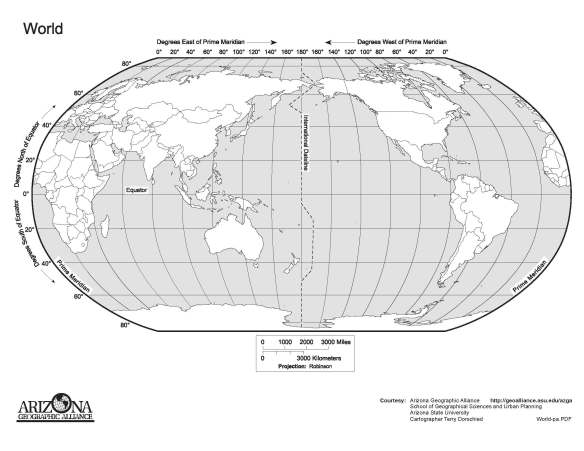
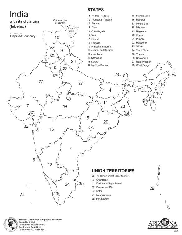
To that end, in trainings I sometimes print out a blank or unlabeled map of a country or region, and ask my learners to fill it in. What better way to realize how much we have to learn? I often use it as a warm-up activity: something for those who arrive early to do while waiting for the on-time arrivals; a way to engage and focus learners.

The problem is finding the maps. I want accurate maps that print in high resolution. And, ideally, I want maps with the “answers,” labeled maps, as well as the blank or unlabeled ones. I would also like them to be free of charge. Enter Arizona State University’s Geographic Alliance, which has free downloadable and printable maps that are very useful for training and education. Be sure to check them out! They have maps for all seven continents, major world regions, and quite a few countries.

India_3pages_Page_3

The Alliance’s mission is to advocate for a geographically literate society. As such, they have elementary and secondary lesson plans focusing on Arizona, the USA, and the world. How wonderful is that? Foci of the lesson plans include GeoStem, GeoMath, GeoHistory, and GeoLiteracy. If you are an educator or play around with kids, be sure to check out their cool curricula! Samples include:

  1. Can You Hear Me Now? How a Country’s Wealth Influences Communication: students use scatter plots to discover relationships between the wealth of a country and the access of its citizens to modern methods of communication.
  2. Don’t Just Escape A Problem, Shape A Solution: An NBA Star’s Efforts to Fight Ethnic Hatred: students will identify the events that led to the formation of Group 7, Vlade Divac’s organization to aid child victims of war. Students will recognize how one person is able to identify a problem and make a positive impact on the world.
  3. From Around the Corner to Around the World: How Technology Helps in the Spread of a Product: students will examine the spread of one product (Coca-Cola) as aided by advances in technology. Students will mark on their maps their estimates of the spread of a product and then mark their maps again after receiving and discussing information. Students will culminate the lesson by writing a summary paragraph.
  4. Go, Buddha, Go: Patterns in the Spread of Religions: students will gain a better understanding of patterns of cultural diffusion, while also reinforcing their knowledge of where religions began and where they spread to.
  5. If These Walls Could Talk: Seeing a Culture Through Human Features: students will identify events that shape a culture, and identify human features in their own community.

Cultural Detective is a renowned process for developing intercultural competence by better understanding oneself, others, and bridging differences so that we harvest the added value of diversity. It is immediately applicable and theoretically grounded, and combines well with a host of other tools, activities and approaches. Maps are just one of these. To read some of our other articles about maps, click here.

40 Maps That Will Help You Make Sense of the World

You’ve seen some of these maps before, but I’ll bet you haven’t seen all of them. A very interesting way to visualize differences in our world from various perspectives. Enjoy!


TwistedSifter


If you’re a visual learner like myself, then you know maps, charts and infographics can really help bring data and information to life. Maps can make a point resonate with readers and this collection aims to do just that.

Hopefully some of these maps will surprise you and you’ll learn something new. A few are important to know, some interpret and display data in a beautiful or creative way, and a few may even make you chuckle or shake your head.

If you enjoy this collection of maps, the Sifter highly recommends the r/MapPorn sub reddit. You should also check out ChartsBin.com. There were also fantastic posts on Business Insider and Bored Panda earlier this year that are worth checking out. Enjoy!


1. Where Google Street View is Available

map-of-the-world-where-google-street-view-is-available

Map by Google


2. Countries That Do Not Use the Metric System

map-of-countires-that-use-metric-system-vs-imperial

View original post 740 more words

Book Review: How Maps Change Things

by Ward L. Kaiser, published by the New Internationalist and ODT Maps, 2012.
Free download through March 31 for Cultural Detectives

Anyone looking to develop a new class or training program to improve intercultural competence? This just-released book, How Maps Change Things: A conversation about the maps we choose and the world we want, could be the basis of one terrific learning journey! I highlighted something on nearly every one of its 188 pages. I learned so much, on so many different yet related topics, that I now have five or six threads of learning and discovery I want to pursue!

At first glance you might think this is a book about maps. Then you read on page six that it is about

“… how we shape and use maps and how they in turn shape us. It’s about how we see the world and how we therefore understand our place in it.”

So you start to hope that How Maps Change Things could teach us to be careful whether we label a certain body of water the “Arabian Gulf” or the “Persian Gulf,” or color-code parts of Kashmir as Indian or Pakistani, but it goes way beyond that.

“Because such maps encourage the feeling that some areas are home to movers and shakers while others shelter mere pawns.” — page 74

Mr. Kaiser, the author, is a big fan of equal-area projection maps such as the Peters, as most in the global diversity and inclusion field are, and points out how maps such as the Mercator aren’t good for much other than navigation. But in addition to showing us how maps can be used to perpetuate bias, he shows us how maps can also be used to promote perspective shifting, equity, and social justice:

“Through internalizing many ways to see the world we may even develop openness to other people’s points of view and greater self-awareness.”
— page 164

“What if people all over the world threatened by, well, you name it – logging, commercial development, polluting factories, hydrofracking chemicals in drinking water, say – what if they could all see maps as tools of analysis and action? …

How about a map to make clear where the hazardous electronic wastes of the developed world get dumped …

Bring together maps, available technology, human creativity, and people’s willingness to take a stand and you’ve got a powerful recipe for changing events.” — page 176

For these reasons and others this volume will be useful to interculturalists and those interested in diversity, sustainability, and social action.

The author premises that maps are tools that serve a purpose.

“Maps are verbs. They may seem to be tactile objects, documents we can handle or fold – nouns – but don’t be fooled. In persuasively framing questions and selectively supplying answers they act; they initiate; they function as agents.” — page 15

To illustrate this point he shares some terrific stories: one about the role of maps in a territorial dispute between First Nations people and the Canadian government (pages 35-39); another about how a map can skew our view of a country as a source of oil or as a residence of people and families (pages 8-17); and a third showing how a map was used to get one county to pay for a highway interchange that served another county (pages 34-35). There is a chapter about the connection between maps and faith/values (chapter 10 page 141), and how maps are used for disease control and health (page 170), as well as for crime prevention (page 173), a topic of special interest lately with concerns of profiling and ethnic bias.

The book is written in a lively, accessible style, though it gets heavier and slower toward the end; ironically, the final chapters are where Mr. Kaiser’s true passion seems to lie. It contains several embedded learning exercises (e.g., page 121) and interesting conversations such as how indigenous North Americans mapped (page 40). Via this latter conversation, he shows that the “culture” of map-makers is not universal. This, to me, is a hugely important point. Too many people believe their area of professional practice is culture-neutral or universal when, in fact, even science is culturally relative (as well as discipline-relative!).

One of the pleasures of reading How Maps Change Things is that it contains quite a few valuable “hidden” gems. One of my favorites: as the author discusses the huge socio-economic gap in our world, variously referred to by such inadequate (or judgment-laden) terms as North-South, 1st/3rd world, Developed/Developing nations, and Viable/Failed states, he provides in the footnotes a list of experts from diverse political persuasions and walks of life who share a consensus on the absolute need to bridge this gap (pages 138-139).

Through March 31 our friends at ODT Maps, the publisher, are offering this ebook FREE to our Cultural Detective community. I urge you to take advantage of this offer and help the author get this book put to good use!

Maps are tools, and can be purposed to perpetuate bias or to help us to create a better world. Cultural Detective has long been passionate about maps as learning tools. Way back in December of 2005 we dedicated an entire edition of our Cultural Detective e-news to maps (including 3 articles of activities and curricular ideas and a quiz), relying in large part on the expertise and generosity of our friends at ODT Maps.

It included: Using Physical Maps to Transform Mental Maps8 Map Activities for Intercultural Learning; a World Map Detective quizTraining with Map Power; and a free offer (a Mecca-centered Azimuthal map, a Peters Projection map, and a Population Map) from our friends at ODT Maps.

Bob Abramms at ODT has a wealth of books, DVDs, globes, puzzles, games, props, and  world maps for different purposes — terrific training material for intercultural and global diversity and inclusion professionals. If you’re not familiar with his great stuff, be sure to check it out.